
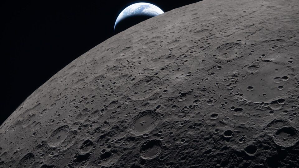
NASA has released more than 800 gigabytes of scientific data from Artemis II, the crewed flight that flew around the Moon in April 2026. The archive, made available on 7 October 2026, includes more than 11,000 full-resolution photographs and video recordings, around 8.5 hours of audio recordings of astronaut observations, annotated images, transcripts and three important technical documents. The data are available to researchers and the public through the Planetary Data System (PDS), NASA’s scientific archive.
For more on NASA, see also Curiosity found 21 organic molecules on Mars. Why “organic” does not automatically mean life, which provides related background on the subject.
This is not simply a gallery of striking photographs. The material gives scientists an opportunity to compare observations made directly by astronauts with earlier measurements from lunar orbiters and data from the Apollo missions. Still, the release of the data does not mean that every image contains a new discovery. Geological interpretations will require analysis and verification, and some findings remain preliminary.
What the Artemis II archive contains: images, audio and annotations
NASA’s 7 October release describes a package of more than 800 GB uploaded to the PDS archive. It includes imagery from cameras handled by the astronauts, photographs and clips taken by Orion spacecraft cameras, recordings of spoken observations, and images on which the crew marked directions or the locations of specific phenomena.
Three reference resources have also been published: the Artemis II Preliminary Lunar Science Report, the Artemis II Lunar Science Operations Report and the Artemis II Lunar Science Data User Guide. The first summarises preliminary observations, the second describes how the science activities were organised and carried out, and the guide helps users interpret the data structure.
In practical terms, the public receives not just individual files but also the context needed to read them. A photograph of a crater is much more useful for research when the time it was taken, the spacecraft’s approximate position, the lens used and the crew’s observations are known.

When Artemis II flew and who was aboard Orion
The mission launched on 1 April 2026 and concluded its journey on 11 April 2026, according to NASA PDS data. The crew comprised three NASA astronauts — Reid Wiseman, Victor Glover and Christina Koch — and Canadian astronaut Jeremy Hansen, representing the Canadian Space Agency.
On 6 April, Orion passed the far side of the Moon, at about 6,545 kilometres from its surface at closest approach, according to the PDS catalogue. The team observed craters, volcanic plains, the transition zone between lunar day and night, and changes in the terrain’s colour and texture.
Artemis II was a crewed flyby mission, not a lunar landing. No crew member set foot on the Moon during this flight. The distinction matters, as many accounts of the Artemis programme mix the aims of future stages with what actually occurred in April 2026.
Why human-taken photographs matter in the age of spacecraft
A robotic spacecraft has clear advantages: it can orbit or photograph a celestial body for long periods, using calibrated sensors and observing regions beyond the reach of a short crewed flight. Astronauts, however, add a complementary perspective. They can notice differences in colour, light or topography, quickly choose a subject of interest and explain verbally why they consider it relevant.
Human experience does not replace spectrometric analysis, photogrammetry or thermal measurements. But crew descriptions can direct the study of images towards areas that might otherwise receive less attention. Astronauts may, for example, notice an unexpected geological formation and adjust the camera’s focus or exposure in real time to document it more effectively.
NASA trained the crew through classroom exercises, simulators and geological field sites. Such training is intended to turn an intuitive observation into a more scientifically useful note, linked to an object’s shape, colour, texture and location.
What the astronauts observed at the boundary between day and night
One area of interest is the lunar terminator, the boundary between the Sun-lit side and the side in darkness. There, light falls at a shallow angle, so long shadows bring out terrain features that can be difficult to identify when the Sun is nearly overhead.
Craters, ridges and impact structures may become easier to interpret visually. Yet an image taken in oblique light can exaggerate the impression of depth unless it is correlated with altimetry and other observations. Researchers must separate lighting effects from the terrain’s actual shape.
Some of the material shows craters including Ohm and Vavilov, which lie in regions with a complex geological history. The shape of terraces, impact rims and central areas may offer clues to processes that occurred when cosmic bodies struck the lunar surface long ago.
Flashes on the Moon: what they may show about micrometeoroids
In preliminary accounts of the flyby, the crew reported several bright flashes observed on the darkened surface, possibly associated with meteoroid impacts. Popular-science articles mention five events confirmed in the initial assessments, while some earlier releases referred to six reported observations. This reflects a difference between the initial reports and later checks, rather than grounds for claiming that two separate sets of events occurred.
A bright flash may indicate energy released in an impact, but analysing it is difficult. Cabin reflections, camera effects and other light sources must be ruled out. If an event is confirmed and located with sufficient accuracy, researchers can compare it with imagery from other instruments to better understand the frequency and distribution of small impacts.
This field matters to future human missions. The lunar surface does not have the atmospheric protection of Earth, and impacts by small bodies and lunar dust are important considerations in the design of equipment and habitats.
A solar eclipse seen from near the Moon
Artemis II also captured an eclipse of the Sun, viewed from the spacecraft’s position relative to the Moon. From that angle, the lunar disc can cover the Sun for far longer than a conventional total eclipse seen from a location on Earth. NASA described about 54 minutes of totality for the observation geometry.
The images offer a rare view of the solar corona, the Sun’s outer atmosphere, and of dimly lit regions of the Moon. They may also show indirect-lighting effects from sunlight reflected by Earth. Interpreting very fine details depends on calibration and on ruling out optical reflections.
Such observations can complement data from heliospheric instruments and continuous solar observations, but they do not replace specialised satellites. The crew had a relatively short period of time and a finite set of cameras, each with technical limitations.
Why the lunar surface appears in different colours
The astronauts’ accounts included subtle differences in colour and brightness. The Moon is often assumed to have a uniform grey shade, but surface materials have differing compositions and structures. Volcanic regions, impact deposits and layers of dust can change the way they reflect light.
Colour seen in a photograph, however, depends on white balance, lighting, exposure and image processing. A bluer patch does not on its own establish the presence of a particular mineral. To make geological claims, images must be compared with spectral observations and terrain data.
That is why NASA released material as close as possible to its original form, along with methodological notes. A dramatic frame on social media may be useful to the public, but research requires the technical information associated with its capture.
How researchers and enthusiasts can access the data
The Planetary Data System maintains organised scientific collections with identifiers, metadata and documentation. The Artemis II Mission — PDS Geosciences Node page lists the available files, including camera photographs, clips and associated data.
For those who do not need hundreds of gigabytes, NASA also provides a page containing the preliminary report and representative images. It is a useful starting point for understanding the results without downloading the entire archive.
File versions are worth checking before they are used in technical projects. Some supporting data may be added in later releases; the PDS said that certain SPICE navigation components had not yet been distributed in the initial delivery.
What NASA will use in future missions
Artemis II’s primary purpose was to demonstrate that the rocket and Orion capsule could safely support a crew on a mission beyond low Earth orbit. The science data are an additional benefit and may help guide the selection of regions and types of observations for later stages, including missions intended to operate near the lunar south pole.
A distant photograph does not automatically establish that a landing site is safe. Detailed terrain, illumination, communications, temperature, access to resources and numerous engineering constraints all matter in site selection. Future studies will combine multiple data sources, including measurements from robotic spacecraft.
InfoBuz discusses a complementary exploration project in its article on a possible lunar navigation system using an optical clock and ultra-stable laser. This is separate research and should not be confused with equipment already installed on Artemis II.
What 800 GB means: not every file is a striking photograph
A very large volume of data may include similar frames, images at different exposures, video, audio and technical documents. Not every file corresponds to an entirely new region, and the number of gigabytes is not in itself an indicator of the number of discoveries.
The archive’s value lies in the combination of observations, timing and documentation. Independent researchers can test interpretations and find details initially overlooked, provided the metadata are sufficiently clear. Open publication also contributes to public trust because the material is not confined to a press release.
Frequently asked questions about Artemis II
Did the astronauts land on the Moon?
No. Artemis II was a crewed mission that flew around the Moon and returned to Earth.
Did NASA release 800 gigabytes or more?
The official release of 7 October 2026 states that it was more than 800 GB.
Are the photographs freely accessible?
NASA makes its scientific data available to the public through the PDS and selections of images through its own portals, subject to the applicable terms of use.
Have all observations already been scientifically confirmed?
No. Some findings are preliminary and will be analysed using additional data.
Why technical documents matter as much as lunar photographs
A photograph without context may be spectacular but difficult to use in research. To compare it with satellite images of the same regions, scientists need to know the camera parameters, capture time, viewing geometry and limitations of the data. NASA’s published documents help reconstruct this information and distinguish real terrain details from the effects of illumination or optical processing.
Audio recordings may be useful in describing the sequence of observations, but not every spontaneous statement by an astronaut should be treated as a geological conclusion. Researchers can check crew reactions against measurements previously made by lunar probes and digital terrain models. That is one advantage of an open archive, which teams outside NASA can also consult.
What to consider when redistributing NASA images
Photographs released by the US space agency are subject to reuse rules specific to government material, while use of the NASA logo or suggesting that an image endorses a product may be subject to separate restrictions. Retaining the NASA credit and the exact description is advisable. An Apollo photograph, a probe image or an artistic reconstruction should not be presented as a new Artemis II photograph. In this case, the image of Earth on the lunar horizon is explicitly identified as an authentic capture from April 2026.
Official sources and notes
- NASA — Artemis II data release, 7 October 2026.
- NASA Planetary Data System — mission archive and metadata.
- NASA Science — preliminary report, guide and images.
- NASA — official flyby photographs, 7 April 2026.
InfoBuz, 10 October 2026. Authentic NASA data and images; preliminary geological interpretations are identified as such. We do not present Artemis II as a lunar-landing mission.









Discuția cititorilor
Ai o opinie sau o întrebare despre acest articol? Spune-ne ce crezi.
Fii primul care deschide discuția.
Te rugăm să păstrezi un limbaj civilizat și să discuți la subiect. Comentariile spam sunt filtrate automat.