
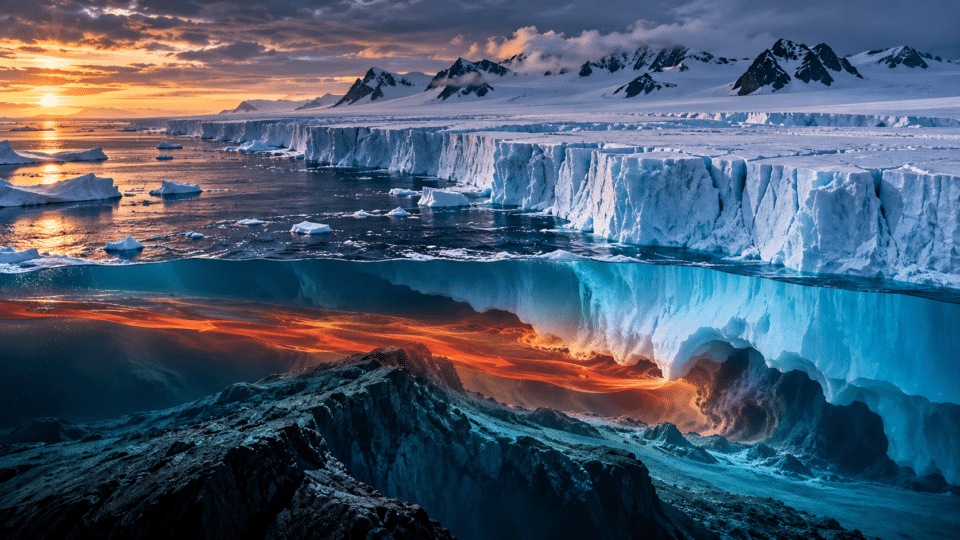
Thwaites Glacier in West Antarctica is one of the planet’s most closely watched ice systems. Not because it might collapse “tomorrow”, as alarmist headlines sometimes suggest, but because the shape of the seabed, relatively warm water reaching beneath the ice and the position of its grounding line make it vulnerable to a retreat that could continue for many generations.
In October 2026, two studies added important evidence. A model calibrated against nearly three decades of observations found that observed retreat is reproduced far more accurately when researchers explicitly include a contact zone several kilometres wide, in which ocean water reaches beneath ice still resting on the seabed. In scenarios with intrusions of about 5 km, Thwaites’ contribution to global sea level reaches about 30 ± 6 mm by 2100 — nearly double some earlier benchmark projections.
Separately, British Antarctic Survey researchers simulated what would happen if ocean-driven melting were stopped completely. Even in this artificial experiment, which is impossible in nature, Thwaites continued to lose ice for 150 years. The message is not that every outcome is inevitable, but that some past changes have already set a persistent dynamic in motion.
Why Thwaites Glacier matters
Thwaites is part of the West Antarctic Ice Sheet and covers an area comparable to the United Kingdom or the US state of Florida. At the point where the ice leaves the seabed and starts floating, the glacier is about 120 km wide.
If all ice in the Thwaites basin capable of contributing to the ocean were lost, the estimated global sea-level equivalent would be about 65 cm. This is not a prediction for this century, nor would such a rise happen instantly. It is the total amount of ice relevant to sea level if the system were eventually to undergo complete loss.
The International Thwaites Glacier Collaboration estimates that ice drained by Thwaites already accounts for around 4% of the current global rate of sea-level rise. More importantly, Thwaites acts as a gateway to inland parts of the West Antarctic Ice Sheet, where much larger quantities of ice rest on bedrock below sea level.
The problem starts beneath the ice, not at the surface
When we see images of Antarctica, the instinct is to look at air temperature. For Thwaites, however, one of the most important factors is the ocean. Relatively warm deep water can enter beneath floating ice shelves and carry heat close to the area where the glacier is still resting on the seabed.
This boundary is called the grounding line. Upstream, the ice rests on bedrock. Downstream, it is light enough to float. The position of this boundary is critically important because it controls how much ice is supported by the seabed and how much can flow more freely towards the ocean.
For a long time, models treated this transition almost as a precise geometric line. Modern satellite observations show that the reality is more complicated.
Ocean water reaches kilometres beneath ice that appeared grounded
In 2024, a team led by Eric Rignot analysed daily-repeat radar images from the ICEYE constellation. The researchers found that Thwaites’ contact area is not a fixed line. Tides push water beneath the ice and draw it back out, creating a grounding zone about 6 km wide in the central part of the glacier and about 2 km wide along its flanks.
The team also detected irregular seawater intrusions extending a further 6 km upstream under certain tidal conditions. The layer of water was very thin — on the order of centimetres — but sufficient to alter where the ice is effectively supported and to carry heat beneath areas previously considered grounded.
This changes the physical problem. If relatively warm water penetrates farther inland than models assume, melting occurs not only beneath the floating ice shelf but may also erode ice near, or within, the contact zone.
October 2026 study: models without this zone do not reproduce the past well
On 12 October 2026, researchers at NASA’s Jet Propulsion Laboratory, the University of California, Irvine, and other institutions published a model in Nature Communications calibrated against observations from 1996 to 2023.
The team tested different lengths for the zone in which ocean water can penetrate beneath the ice, along with different basal melt rates. It then compared the results with three independent sets of observations: the grounding-line position, glacier velocity and ice thinning.
The conclusion was clear: models that include an active melting zone of around 2–5 km reproduce nearly three decades of retreat, thinning and acceleration much more successfully. Without this zone, the model struggles to reproduce all observations simultaneously.
In other words, the process observed from satellites is not simply a local detail. It may be one of the missing pieces explaining why Thwaites has changed more rapidly than some simplified models suggested.
An important threshold: detachment from Mouginot Ridge
At present, the main and fastest-flowing part of Thwaites is still partly stabilised by a seabed rise known as Mouginot Ridge. This feature acts as a support point: ice remains pinned on it, slowing the retreat.
The 2026 model suggests, however, that melting in the grounding zone may weaken this anchoring point. In some simulations consistent with observations, the glacier could detach from the ridge as early as around 2038.
This is not an exact date for a “collapse”. It is the earliest detachment timing in a family of calibrated simulations. After detachment, the glacier would continue retreating across a seabed that, in some sectors, deepens inland — a geometry that can favour continued retreat.
Why a seabed that deepens inland is risky
Much of West Antarctica sits on bedrock below sea level. In some regions, the seabed gets deeper farther into the continent. This geometry is known as a retrograde slope.
For related context, see also The Black Sea’s anoxic zone: a world without oxygen, where methane, sulphur and microbes replace fish, which provides further relevant information.
If the grounding line retreats into deeper water, the ice thickness at the contact point can increase. Thicker ice can flow faster towards the ocean, which may encourage further retreat. The process is known as marine ice-sheet instability.
That does not mean every retreat automatically becomes irreversible or rapid. Bedrock, friction, topography, snowfall accumulation and ocean temperature can slow or accelerate the process. This is precisely why direct evidence about the ground beneath Thwaites is so important.
How much could Thwaites raise sea level by 2100?
The October 2026 study does not project the glacier’s complete loss by the end of the century. Instead, its authors constructed a deliberately controlled scenario in which climate forcing was kept roughly at the average level observed between 1996 and 2023.
The aim was to isolate the effect of the grounding zone. In this setup, without an explicit zone of water intrusion, Thwaites’ modelled contribution is around 8.3 ± 3.0 mm by 2100.
With a zone of about 3 km, the contribution rises to about 19.4 ± 5.2 mm. With a zone of about 5 km — consistent with modern observations of intrusion — the model reaches 30.1 ± 5.7 mm.
It is important not to turn 30 mm into a “guaranteed prediction”. The authors present it as a baseline scenario that holds climate forcing constant. Future ocean warming, changes in circulation or other processes could alter the outcome.
Why three global centimetres matter more than they seem
A global mean rise of a few centimetres may sound small when compared with waves or tides. But mean sea level is the baseline on which tides, storms and storm surges are superimposed.
If that baseline rises, the same weather event can produce more frequent flooding and reach farther inland. The impact is not uniform: gravity, ocean circulation, land subsidence and crustal movement mean that regional sea level differs from the global average.
Thwaites’ contribution is also added to those from Greenland, other glaciers, the ocean’s thermal expansion and the rest of Antarctica. The real risk comes not from a single isolated figure, but from the sum of these contributions.
The glacier keeps losing ice even if ocean melting is “stopped”
Just one day after the Nature Communications study, the British Antarctic Survey released the results of separate research. The authors used three independent models in an extreme experiment: they entirely removed ocean-driven melting beneath Thwaites and Pine Island glaciers.
Pine Island responded broadly as expected: it thickened and began to advance towards earlier positions. Thwaites, however, continued to lose ice in every simulation for 150 years, although its rate of loss gradually declined.
This scenario cannot occur in the real world — seawater beneath the ice always produces some melting. The experiment was designed to test how much “memory” the system has. Its result suggests that past changes have pushed the glacier into a state in which internal dynamics sustain part of the loss even after external forcing is artificially removed.
Does this mean emissions cuts no longer matter?
No. That would be the wrong conclusion. The fact that some loss is already committed does not mean the scale and pace of future loss are fixed.
In the real world, the ocean continues to carry heat beneath the glacier, and future temperatures and circulation will influence how quickly the system retreats. BAS authors stress that further warming could worsen the remaining ice loss.
The International Thwaites Glacier Collaboration’s 2025 final report reaches the same conclusion: complete collapse in the next few decades is considered unlikely, but the glacier is expected to retreat further and faster during the 21st and 22nd centuries. Rapid emissions reductions remain the best way to delay ice loss and avoid triggering similar processes in other marine sectors of Antarctica.
Why “Doomsday Glacier” is a problematic name
Thwaites is often called the “Doomsday Glacier” in the media. The label draws attention, but it can create two mistaken impressions: that collapse is imminent, and that a single catastrophic event will suddenly raise the oceans.
The reality is slower and, for that reason, more difficult. These are processes unfolding over decades and centuries, with periods of acceleration, periods of slowing and major uncertainties. The risk is not a day on which Thwaites “falls”, but a trajectory of retreat that may require coastal cities to adapt permanently.
The International Thwaites Glacier Collaboration explicitly says that a complete collapse is unlikely in the next few decades. Articles presenting 65 cm as a near-term rise do not reflect the current consensus.
The Icefin robot showed that melting is not uniform
One of the International Thwaites Glacier Collaboration’s most striking expeditions used the Icefin underwater robot, sent beneath the ice shelf through a hot-water-drilled borehole. Images and measurements showed that water beneath the ice was more than 2°C warmer than the local freezing point.
Yet flat surfaces were not melting as quickly as the temperature suggested. A stable layer of cold, fresh meltwater limited heat transfer. Sloping walls, terraces and crevasses, by contrast, showed much more intense melting.
This is an important lesson for models: knowing ocean temperature is not enough. Ice geometry, currents and stratification can concentrate melting in some places and suppress it in others.
Subglacial water can temporarily double melting
A study published in 2025 added another piece to the picture. Beneath Thwaites are subglacial lakes and freshwater networks. When one such reservoir drains, fresh water can enter the ocean cavity beneath the ice shelf and form an upwelling current.
During one observed event, researchers estimated that this discharge temporarily doubled ocean-driven melting beneath the Thwaites ice shelf. The process shows how closely linked hydrology beneath the glacier is to the ocean in front of it.
Climate and ice-sheet models will need to progressively incorporate these processes if estimates of the future pace of loss are to become more precise.
What lies beneath Thwaites may determine the pace of retreat
The bed beneath the glacier is not uniform. Seismic and radar research has identified areas of hard bedrock, sediments and zones with differing drainage properties. These differences control the amount of friction between ice and the bed, and how subglacial water circulates.
In 2026, a study of geology beneath Thwaites described sharp contrasts between bedrock sectors and softer, wetter regions. These structures may locally slow ice flow or provide routes through which water is redistributed.
For readers interested in the continent’s hidden world, InfoBuz has separately explained what lies beneath Antarctica’s ice: mountains, valleys, lakes and basins far below sea level. Thwaites is one of the regions where this invisible geography directly affects the future of global coastlines.
Could Thwaites destabilise the rest of West Antarctica?
The greatest concern is not Thwaites’ 65 cm of sea-level equivalent alone. The glacier and its neighbours drain an important part of West Antarctica, and their retreat may alter how ice from the interior reaches the ocean.
The West Antarctic Ice Sheet as a whole contains enough ice to raise global mean sea level by about 5 metres. No one projects the loss of that amount in a single century, but studies are examining whether the retreat of glaciers such as Thwaites could, over the long term, facilitate the loss of much larger basins.
The 2025 ITGC report says that a broad retreat of the West Antarctic Ice Sheet during the 21st and 22nd centuries cannot be ruled out. That justifies intensive monitoring, without turning century-scale scenarios into predictions for the next few years.
What this means for coastal cities
For urban planning, the difference between a lower and a higher sea-level scenario is substantial. Infrastructure built today — ports, seawalls, drainage systems, airports and coastal neighbourhoods — may operate for 50 to 100 years.
That means seemingly slow processes in Antarctica are already within the lifespan of infrastructure. A city cannot wait for uncertainty to fall to zero before deciding the height of a seawall or the standard for a new building.
InfoBuz has also examined why climate change should be assessed through measurable effects and scenarios, rather than temperature records alone. Thwaites is a clear example: what matters to society is not only ocean temperature, but how it translates into centimetres of sea-level rise and flood risk.
What to watch in the coming years
- Grounding-line position: whether retreat continues and when the main part of the glacier detaches from Mouginot Ridge.
- Length of ocean intrusions: how far water reaches beneath apparently grounded ice.
- Ocean temperature and circulation: changes in deep water in the Amundsen Sea may accelerate or slow melting.
- The condition of floating ice shelves: crevasses and the loss of supporting areas may reduce buttressing.
- Subglacial hydrology: freshwater discharges may alter melting and basal friction.
- Satellite observations: daily-repeat radar constellations make it possible to detect processes that older satellites could miss.
A glacier does not change the map of coastlines in a day — it does so centimetre by centimetre
The real story of Thwaites is more compelling than the “Doomsday Glacier” label. Satellites have shown that ocean water can penetrate kilometres beneath the ice. The 2026 models suggest that including this process doubles the projected sea-level contribution in a baseline scenario. Other simulations show that some loss continues even when ocean melting is artificially removed.
But there is no date on which Thwaites “will fall”. There is a series of physical thresholds, each with its own uncertainties: detachment from seabed rises, retreat over retrograde slopes, weakening of floating ice shelves and changing ocean circulation.
For people living on the coast, the difference between a more slowly retreating Thwaites and an accelerating one is not abstract. It may mean additional decades for adaptation — or extra centimetres beneath every future storm, tide and storm surge.
Frequently asked questions about Thwaites Glacier
How much would sea level rise if Thwaites were lost completely? About 65 cm globally, but this figure represents the total ice equivalent and is not a prediction for the coming decades.
Will Thwaites collapse in the next few years? Current evidence does not support a complete collapse in the next few decades. The ITGC nevertheless expects continued, and probably faster, retreat in the 21st and 22nd centuries.
Why is water beneath the ice dangerous? Relatively warm ocean water can melt the base, shift the grounding line inland and reduce contact between the ice and the seabed.
What does the figure of 30 mm by 2100 mean? It is the result of a 2026 simulation with a grounding zone of about 5 km and climate forcing held at the recent average level. It is not an exact or inevitable prediction.
Why is some loss described as already “committed”? A 2026 BAS study found that Thwaites continued losing ice for 150 years in simulations even when ocean melting was artificially stopped, indicating persistent effects from past changes.
Do emissions cuts still matter? Yes. Future loss does not have a single predetermined value. Additional warming can accelerate the processes, while limiting warming can reduce their pace and buy time for adaptation.
Sources and transparency
- Nature Communications – Sea-level contribution from Thwaites Glacier doubles in an observation-constrained ice-sheet model, 12 October 2026
- British Antarctic Survey – Thwaites Glacier will keep losing ice even if oceans cool, 13 October 2026
- Geophysical Research Letters – Mass loss from Thwaites Glacier continues even without ocean melting, 2026
- PNAS – Widespread seawater intrusions beneath the grounded ice of Thwaites Glacier, 2024
- Nature – Heterogeneous melting near the Thwaites Glacier grounding line, 2023
- Nature – Suppressed basal melting in the eastern Thwaites Glacier grounding zone, 2023
- Nature Communications – Subglacial lake discharge and Thwaites ice-shelf melting, 2025
- International Thwaites Glacier Collaboration – Key Research Findings, 2025
- International Thwaites Glacier Collaboration – Thwaites Glacier Facts








Discuția cititorilor
Ai o opinie sau o întrebare despre acest articol? Spune-ne ce crezi.
Fii primul care deschide discuția.
Te rugăm să păstrezi un limbaj civilizat și să discuți la subiect. Comentariile spam sunt filtrate automat.